 There are currently 5 active NOAA satellites transmitting pictures of the planet in real time by radio: NOAA-15, NOAA-18, NOAA-19, NOAA-20 and NOAA-21. These polar-orbiting satellites build up an image of the Earth from successive passes.
  The pictures sent by NOAA satellites are transmitted via two transmitters. The first transmits the image in ultra-high resolution (HRPT format) and requires the use of a dish that must follow the satellite’s trajectory in order to be received.
 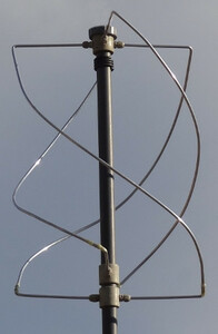 The second transmits the pictures in high resolution (APT format) and requires a QFH (QuadriFilar Helix) antenna. It is the latter that is received by the F4BPP reception station in Marseille to decode the images.
The frequency range used to transmit images in APT format extends from 137.100 MHz to 137.9215 MHz (VHF band).
The second transmits the pictures in high resolution (APT format) and requires a QFH (QuadriFilar Helix) antenna. It is the latter that is received by the F4BPP reception station in Marseille to decode the images.
The frequency range used to transmit images in APT format extends from 137.100 MHz to 137.9215 MHz (VHF band).  The pictures transmitted consist of two black and white photographs. When the area photographed by the satellite is lit by the sun, the satellite uses the high-resolution radiometer and the infrared radiometer to transmit the images. When the area photographed by the satellite is in shadow, the satellite uses two different infrared radiometers.